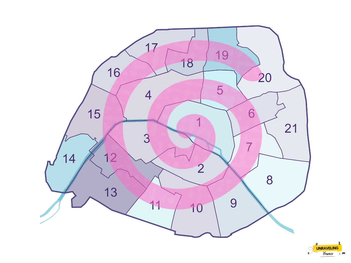
If you look closely at a map of Paris, you’ll notice the city’s twenty districts are arranged in a spiral pattern that widens as it moves outward from the center, creating a layout often compared to a snail’s shell. But why this choice? Here’s a look at the history and surprising factors behind this distinctive design.
Paris’s Layout: From Administrative Necessity to Spiral Design
Paris is one of the few French cities, along with Lyon and Marseille, that is divided into districts (arrondissements), each with its own local government. This structure initially helped manage a rapidly growing population.
However, it wasn’t always this way. Back in 1795, when Paris had around 100,000 residents, the city’s management was complex. To streamline administration, it was divided into twelve arrondissements arranged in a west-to-east, north-to-south order—without any spiral pattern yet.
Haussmann’s Task: Expanding Paris and Facing a Challenge
The major shift came in 1859, under Napoleon III’s rule, when Paris expanded to include the neighborhoods within the Thiers fortifications. Georges-Eugène Haussmann, chosen by Napoleon III, was tasked with redesigning Paris. His initial plan divided the city into twenty arrondissements to incorporate these new areas.
However, an unexpected issue arose: in Haussmann’s original plan, the new 13th arrondissement was set to be located in the western part of Paris, where today’s 16th arrondissement lies. At that time, there was a popular phrase, “to marry at the town hall of the 13th arrondissement”, which actually meant living together without marriage, as there was no 13th arrondissement in the city’s original layout. The wealthy residents of Auteuil and Passy, neighborhoods designated to become part of this 13th, were strongly opposed to this association, considering it beneath their social status.

In response, Haussmann adapted his design, arranging the arrondissements in a clockwise spiral starting from the historic center of Paris (the 1st arrondissement, near the Louvre). This clever layout shifted the planned 13th arrondissement to a popular neighborhood in eastern Paris, while the wealthy areas of Auteuil and Passy became part of the 16th.
A Fixed Layout, But Modern Adjustments
The spiral layout adopted in 1859 has largely remained unchanged, though it has led to some differences in population density and resources between central and outer arrondissements. Recently, a reform has addressed these imbalances: in 2020, the first four arrondissements were merged into a single administrative entity known as “Paris Centre.” This consolidation shows that Paris’s district organization may continue to evolve to meet the city’s needs.
Thus, the spiral arrangement of Paris’s arrondissements, born from a mix of administrative and social pressures, has become a unique feature of the city, symbolizing its rich history and adaptability while preserving its iconic character.

